
24 July 2012 , ROCHESTER, N.Y.-- Each day, thousands of businesses and government organizations are moving their data to a cloud-computing environment, providing anytime, anywhere access to critical information. With today’s launch of Pictometry® Connect™, the power of the cloud has come to aerial imaging, combining the company’s vast library of 145 million, high-resolution aerial oblique images with customer-specific GIS data. The result is the industry’s most capable and easily deployable solution for on-demand visual intelligence.
“Not only will they be able to map their own exclusive data against the world’s highest quality aerial oblique image library, but they’ll also have optional access to additional, Pictometry-produced data sets. It’s an elegant, streamlined solution that has the potential to further empower their in-house teams, projects and programs.”
Current solutions can create installation and ongoing interoperability challenges with existing software packages. Pictometry Connect – thanks to its cloud-based, standards-driven approach – operates differently, allowing turnkey integration with leading GIS and CAD applications, as well as existing workflows. Deployment can occur at the desktop, via a local server or through a Web browser interface.
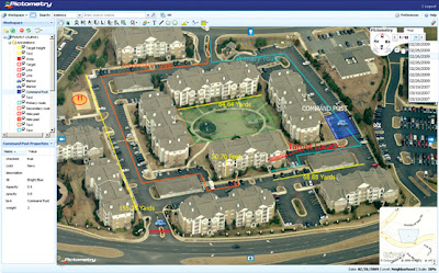
With professional-quality aerial imagery being stored in the cloud to ensure world-class management and updates, customers no longer have to continually manage and update terabytes of imagery on their own servers. Instead, they securely upload their own location-based data sets to Pictometry Connect, which are then layered on the images alongside proprietary measurement and analytics tools to deliver unparalleled visual insights.
“Pictometry Connect represents a significant advance in how our commercial and government partners will be able to derive even more value from their GIS data,” said James Smyth, Pictometry’s chief marketing officer. “Not only will they be able to map their own exclusive data against the world’s highest quality aerial oblique image library, but they’ll also have optional access to additional, Pictometry-produced data sets. It’s an elegant, streamlined solution that has the potential to further empower their in-house teams, projects and programs.”
Unlike traditional orthogonal – or top down – aerial and satellite capture, Pictometry’s high-resolution oblique images show each side of every structure, roadway and other outdoor objects, with views from all four cardinal directions. Since each pixel is individually geo-referenced, users can quickly and precisely measure geographic position, height, distance, and altitude directly on the images in real-time. The new cloud-based solution also provides access to up to 10 years of imagery, permitting robust, pixel-for-pixel change analysis.
For additional information, please visit www.pictometry.com or speak with company representatives during the Esri International User Conference from July 23 – 27 at the San Diego Convention Center (Booth #1000).
About Pictometry
Pictometry International Corp. is the leading provider of data-rich aerial imagery, analytics, integrations and reports, utilizing its patented technology. Geo-referenced and accurate for location-based planning, high resolution Pictometry Intelligent Images™ enable users to measure sites and structures for area, distance, height, elevation and more directly from their computers or mobile devices. Professionals in the assessment, insurance, construction, oil & gas and other industries – plus government agencies – use Pictometry imagery daily, overlaying it with GIS data and integrating it into existing systems to create enterprise-wide productivity tools. The company’s vast image library of 145 million data-rich images is continually updated and includes assets from 150 countries and territories around the world. To learn more, visit www.pictometry.com or follow @Pictometry on Twitter.

“Not only will they be able to map their own exclusive data against the world’s highest quality aerial oblique image library, but they’ll also have optional access to additional, Pictometry-produced data sets. It’s an elegant, streamlined solution that has the potential to further empower their in-house teams, projects and programs.”
Current solutions can create installation and ongoing interoperability challenges with existing software packages. Pictometry Connect – thanks to its cloud-based, standards-driven approach – operates differently, allowing turnkey integration with leading GIS and CAD applications, as well as existing workflows. Deployment can occur at the desktop, via a local server or through a Web browser interface.
With professional-quality aerial imagery being stored in the cloud to ensure world-class management and updates, customers no longer have to continually manage and update terabytes of imagery on their own servers. Instead, they securely upload their own location-based data sets to Pictometry Connect, which are then layered on the images alongside proprietary measurement and analytics tools to deliver unparalleled visual insights.
“Pictometry Connect represents a significant advance in how our commercial and government partners will be able to derive even more value from their GIS data,” said James Smyth, Pictometry’s chief marketing officer. “Not only will they be able to map their own exclusive data against the world’s highest quality aerial oblique image library, but they’ll also have optional access to additional, Pictometry-produced data sets. It’s an elegant, streamlined solution that has the potential to further empower their in-house teams, projects and programs.”
Unlike traditional orthogonal – or top down – aerial and satellite capture, Pictometry’s high-resolution oblique images show each side of every structure, roadway and other outdoor objects, with views from all four cardinal directions. Since each pixel is individually geo-referenced, users can quickly and precisely measure geographic position, height, distance, and altitude directly on the images in real-time. The new cloud-based solution also provides access to up to 10 years of imagery, permitting robust, pixel-for-pixel change analysis.
For additional information, please visit www.pictometry.com or speak with company representatives during the Esri International User Conference from July 23 – 27 at the San Diego Convention Center (Booth #1000).
About Pictometry
Pictometry International Corp. is the leading provider of data-rich aerial imagery, analytics, integrations and reports, utilizing its patented technology. Geo-referenced and accurate for location-based planning, high resolution Pictometry Intelligent Images™ enable users to measure sites and structures for area, distance, height, elevation and more directly from their computers or mobile devices. Professionals in the assessment, insurance, construction, oil & gas and other industries – plus government agencies – use Pictometry imagery daily, overlaying it with GIS data and integrating it into existing systems to create enterprise-wide productivity tools. The company’s vast image library of 145 million data-rich images is continually updated and includes assets from 150 countries and territories around the world. To learn more, visit www.pictometry.com or follow @Pictometry on Twitter.


