Digital Orthophotos have become premiere geospatial data products in recent aerial photogrammetry mapping. Although they are often used as background context for the display of vector data, there is quite a bit of complexity that can go into creating them. If you've ever looked into purchasing orthos, you may have been given the option of buying "true orthos".Compared with regular orthos, true orthophotos seemed offensively expensive.
If orthophotos can be characterized as images that are geometrically corrected for relief variation, true orthophotos add the dimension of correcting for the distortion of buildings. Or, simply stated, true orthophotos do not show building lean. This is important for mapping applications such as digitizing street centerlines in Lower Manhattan. "Normal" orthophotos will show displacement of skyscrapers and many of the streets will be obscured. It isn't a major issue in suburban or rural environments, but may be necessary for urban environments such as Hong Kong, NYC, Seoul, and other metro environments with a large number of skyscrapers. True orthos can also be important for transportation planning projects, such as accurately mapping bridges.
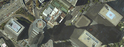
Here is an example: the ortho of central Los Angeles below shows building lean that is common in many urban environments. The facades of the skyscrapers are clearly visible, and the surrounding areas on the ground are obscured. Yahoo Maps for the same area shows a similar effect.
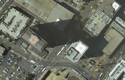
This next image shows what a "true ortho" would look like (a different part of central LA). The only way to tell the buildings are highrises, other than the giveaway helicopter landing pads, is the long shadows cast by the two buildings in the center.
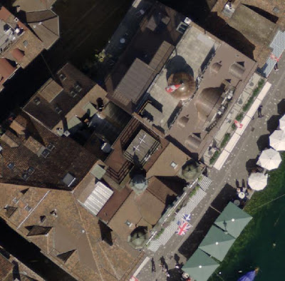
Here is another application featuring a couple of buildings in Lucerne, Switzerland. Although these buildings are not skyscrapers, the effect is clearly visible. The building facade is readily displayed in the image below.

The next image, of the exact same building, shows a top down view that does not display building sides.